Log in
All resources
Create a design
2,977 Free Artworks of City Map
bibliothèque nationale de france
eran laor cartographic collection
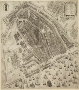
map of amsterdam by julius milheuser after daniël stalpaert, 1662
julius milheuser
beschreibung der städt der welt - braun & hogenberg - btv1b52512111k
baroque
maps of paris from bibliothèque nationale de france
french-language maps
matthäus merian
maps by willem and johannes blaeu
adolf eltzner, svate mesto jerusalem za casu krista pana, 1864
eran laor cartographic collection
adolf eltzner, svate mesto jerusalem za casu krista pana, 1864
eran laor cartographic collection
maps in the british museum
old maps of chester
adolf eltzner, svate mesto jerusalem za casu krista pana, 1864
eran laor cartographic collection
eran laor cartographic collection
guillaume dheulland
history of bernkastel-kues
city walls of bernkastel
old maps of manhattan, new york city
jasper danckaerts
map of amsterdam by julius milheuser after daniël stalpaert, 1662
engraving
cities in the 1640s
baroque
kobe foreign settlement
old maps of kobe
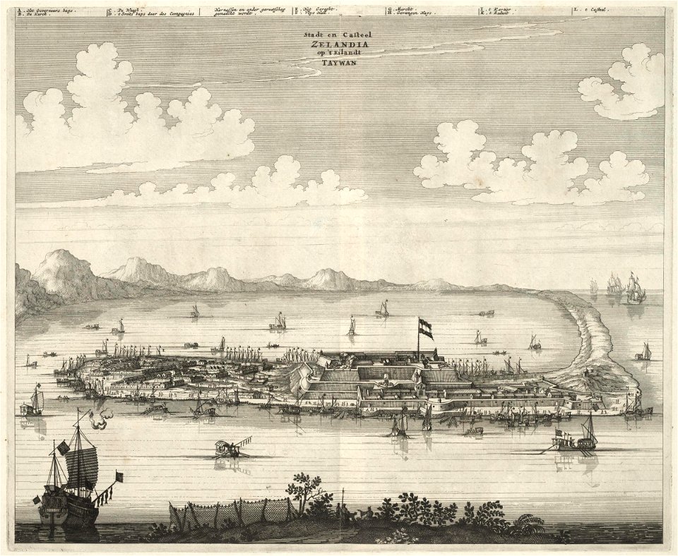
1670s works in taiwan
1670 maps
woodcuts in the universitätsbibliothek salzburg
wolf-dietrich-klebeband städtebilder
old maps of seville
1788 maps of spain
victor levasseur - maps of france
19th-century maps of finistère
eran laor cartographic collection
nicolas langlois
city walls of lechenich
baroque
maps of utrecht (city) city walls
old maps of utrecht (city)
maps of paris from bibliothèque nationale de france
maps of paris by louis-joseph mondhare
maps in the library of congress
1841 maps of massachusetts
eran laor cartographic collection
afbeeldinge der stad jerusalem
eran laor cartographic collection
afbeeldinge der stad jerusalem
old maps of groningen (city)
egbert haubois
munich in the 17th century
baroque
prints in the stadsarchief amsterdam
map of amsterdam, 1544
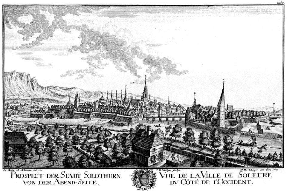
engravings of cities in switzerland
1757 in switzerland
old maps of valletta
baroque
sanson maps of south america
1719 maps of south america
map of amsterdam by julius milheuser after daniël stalpaert, 1662
julius milheuser
map of amsterdam by julius milheuser after daniël stalpaert, 1662
julius milheuser
map of amsterdam by julius milheuser after daniël stalpaert, 1662
julius milheuser
map of amsterdam by julius milheuser after daniël stalpaert, 1662
julius milheuser
map of amsterdam by julius milheuser after daniël stalpaert, 1662
julius milheuser
map of amsterdam by julius milheuser after daniël stalpaert, 1662
julius milheuser
map of amsterdam by julius milheuser after daniël stalpaert, 1662
julius milheuser
maps from university of amsterdam special collections
atlas der neederlanden
print room of the university of antwerp
citadel van antwerpen
maps by willem and johannes blaeu
atlas van loon
eran laor cartographic collection
afbeeldinge der stad jerusalem
eran laor cartographic collection
jacques chereau
atlas maior, vol 2 (sweden, russia, poland, eastern europe, and greece) - joan blaeu, 1667 - bl 114.h(star).2
1667 maps of russia
maps by tomas lopez
1785 maps
topographia bohemiae moraviae et silesiae (merian)
baroque
amsterdam in the 1590s
pieter bast
jacques-nicolas bellin
1773 maps of africa
hendrik de leth
1737 maps
maps of aachen by braun & hogenberg
city walls of aachen
maps of antwerp by braun & hogenberg
city map
maps by john cary
1806 maps of asia
maps of ingolstadt by braun & hogenberg
maps of munich by braun & hogenberg
maps of the dutch east india company - thailand
old maps of ayutthaya
antoine-françois tardieu
maps from gallica
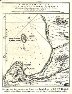
charts and maps of the royal museums greenwich
1777 maps
eran laor cartographic collection
nicolas langlois
maps of aachen by braun & hogenberg
city walls of aachen
maps of aachen by braun & hogenberg
city walls of aachen
portrait of george washington by giuseppe perovani
1790s maps of washington, d.c.
engravings by jan luyken
old maps of antwerp
plan routier de la ville et faubourg de paris by jean lattré
maps of paris from bibliothèque nationale de france
plan routier de la ville et faubourg de paris by jean lattré
maps of paris from bibliothèque nationale de france
plan routier de la ville et faubourg de paris by jean lattré
maps of paris from bibliothèque nationale de france
maps from traité de la police, bibliothèque nationale de france
third map of paris from traité de la police
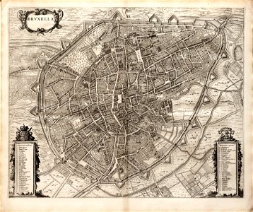
maps of brussels city walls
old maps of brussels
old maps of the london underground
maps by macdonald gill
maps in the library of congress
1758 maps of cuba
coats of arms of cities in nièvre
andré dupin
hamburger stadtentwässerung
1864 maps of hamburg
copper engravings by benjamin cole
maps of the city of westminster
maps by willem and johannes blaeu
old maps of groningen (city)
palatinatus rheni (merian)
baroque
maps by willem and johannes blaeu
old maps of emden
7th portuguese india armada (almeida, 1505)
maps of cefala by braun & hogenberg
maps of groningen by braun & hogenberg
martinikerk (groningen)
très riches heures du duc de berry
early netherlandish painting
new york and brooklyn, with jersey city and hoboken water front
maps in the library of congress
media from the national library of finland
classicism
maps of famagusta by braun & hogenberg
list of cities with defensive walls
flandria illustrata
old maps of lille
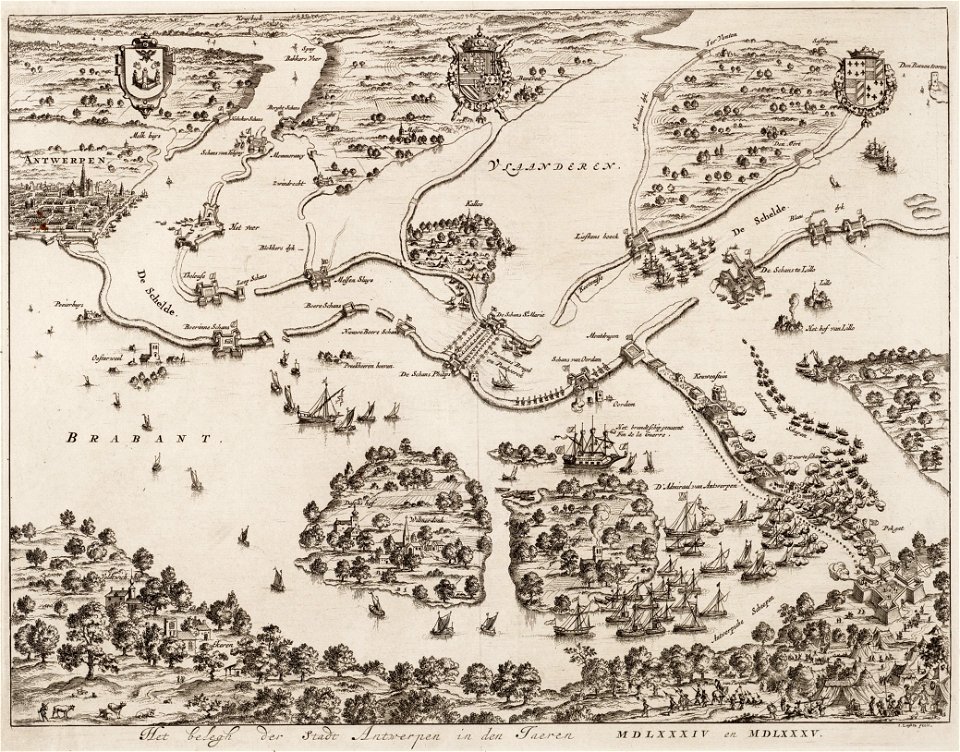
siege of philippsburg (1676)
17th-century fortress plans
beschreibung der städt der welt - braun & hogenberg - btv1b52512111k
maps of kleve by braun & hogenberg
beschreibung der städt der welt - braun & hogenberg - btv1b52512111k
maps of hormuz by braun & hogenberg
beschreibung der städt der welt - braun & hogenberg - btv1b52512111k
maps of braunschweig by braun & hogenberg
beschreibung der städt der welt - braun & hogenberg - btv1b52512111k
maps of casablanca by braun & hogenberg
beschreibung der städt der welt - braun & hogenberg - btv1b52512111k
maps of neuss by braun & hogenberg
beschreibung der städt der welt - braun & hogenberg - btv1b52512111k
maps of valletta by braun & hogenberg
beschreibung der städt der welt - braun & hogenberg - btv1b52512111k
maps of parma by braun & hogenberg
maps of antwerp city walls
old maps of antwerp
1866 in the netherlands
maps of almelo
smedslätten
ålsten
maps of amersfoort by braun & hogenberg
rce suggested: stadsplattegrond
maps of amersfoort by braun & hogenberg
rce suggested: stadsplattegrond
english-language maps
1747 maps of asia
maps of paris from paris musées
dheulland map of paris
charts and maps of the royal museums greenwich
1778 maps of new york (state)
plan routier de la ville et faubourg de paris by jean lattré
maps of paris from bibliothèque nationale de france
maps of strasbourg in the 17th century
works by johann adam seupel
16th-century maps of amsterdam
lodovico guicciardini
maps in the staats- und universitätsbibliothek hamburg
maps of hamburg-altstadt
1800s maps of egypt
maps by john cary
gardens in the vatican city
high renaissance
1762 maps of north america
maps by tomas lopez
301 - 400 of 2,977
Next page
/ 30